
Nearly Half the Homes on America's New Wildfire Risk Map Are Outside California
By Cameron Hale. Aug 13, 2026
The Map Got Bigger, and It Reached Past the Places You’d Expect
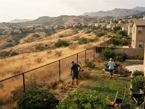
A new analysis released Tuesday puts roughly 2.5 million homes across the American West in the path of wildfire, carrying a combined $1.4 trillion in reconstruction value. The report, from the property-data firm Cotality, spans ten western states - and its most striking finding is not the total. It is that nearly half of the at-risk homes sit outside California, the state most people picture when they picture wildfire.
That single fact reframes the whole conversation. Wildfire exposure has stopped being a California story and become a regional one, and the map now runs through metros that have never thought of themselves as fire country.
Where the Exposure Actually Sits
California still carries the heaviest load by far: about 1.28 million at-risk properties worth an estimated $850 billion. But the rest of the map fills in fast behind it. Colorado and Texas together account for roughly 560,000 properties and $252 billion in value, and seven more states - Oregon, Arizona, Idaho, New Mexico, Montana, Washington and Utah - add another $277 billion combined.
Spread across ten states, the exposure stops looking like a coastal problem and starts looking like a western one. The dollar figures are large, but the more useful number is the count of households: 2.5 million front doors, in ten states, that a risk model now flags.
The Cities That Don’t Think of Themselves as Fire Country
The metro list is where the report gets personal. Los Angeles leads it, with about 250,000 exposed properties and $209 billion in value. But right behind the familiar names sit places the wildfire conversation usually skips: Austin, with more than 100,000 at-risk properties and nearly $50 billion in value, along with San Antonio, Denver and Spokane, all among the ten most-exposed metros in the country.
For a homeowner in one of those cities, that is the shift that matters. The risk did not necessarily rise this week; the ability to see it did. A house that never appeared on a fire map is now a data point on one.
Why the New Numbers Run Higher Than the Old Ones
Part of what widened the map is a change in how the risk is measured. Older models tend to score a property mostly on its own terrain and vegetation. The newer approach layers in what the report calls conflagration risk - the danger that fire spreads house to house through a dense neighborhood rather than jumping in from open land.
That single adjustment can add as much as 40 points to an individual property’s risk score, which is why a home that once looked safe on paper can now read as exposed. It also means two houses on the same street can score very differently depending on what sits between them and their neighbors.
What This Does to the Question of Insurance
The practical stakes land at the mailbox, in the form of a policy. For the last few years, the insurance story in the West has been about broad retreats - carriers pulling out of whole regions at once. The value of a map this granular, the report argues, is that it lets insurers sort house by house instead, distinguishing a well-prepared home from a vulnerable one on the same block.
That cuts both ways for homeowners. The report found that properties in the top 10 percent for mitigation carried expected losses roughly 78 percent below the statewide average, while the bottom 10 percent ran about ten times higher. In other words, the same tool that could keep coverage available for a defensible home is the one that could price out the house next door.
What Is Still Unsettled
The map now exists in enough detail to sort a neighborhood down to the individual address. What no report can answer yet is what everyone does with it - whether carriers use the granularity to keep writing policies in the West or to narrow them further, and whether homeowners in newly flagged cities treat the flag as a warning or a warning shot. For 2.5 million households across ten states, the risk was already there. As of this week, so is the number attached to it.
References: Cotality 2026 Wildfire Risk Report: 2.5M Properties, $1.4T Exposed (HousingWire) | More Than $12 Trillion in US Homes Face Severe Climate Risks, Realtor.com Finds (PR Newswire)

The News Command team was assisted by generative AI technology in creating this content
Trending





Read More


Read More

Read More


Read More



Read More


Read More

Read More

Read More

Read More

Read More

Read More

Read More

Read More

Read More